(NOTE: CTRL+SCROLL WHEEL to increase or decrease font.)

Some Basics of Cycle
Touring 1.
Logistics 2.
Camping 3.
Gear Tauru Chaw
& Christiana Bruchok Ever
thought about riding a bike across the country?
It’s actually not as bad as it seems.
Three-thousand miles can be intimidating, but taking it from one town to
the next, one day at a time, the journey will unravel with tons of memories and
a great sense of accomplishment. At
first, we thought you had to be a super-athlete in order to accomplish such a
feat; but as it turned out, it wasn’t bad at all. We’re athletic, but more importantly we like
to be out there and doing things. And that’s
what it took! And trust us, after the
first week or so on the bike, you’ll be in good-enough shape to pedal the rest
of the 3,000 miles! We
definitely encourage you to consider it.
It’s an experience that you’ll gloat with for the rest of your
life. If you are thinking about it, here
are some of the nuts and bolts: 1. Logistics 2. Camping 3. Gear 1.
Logistics Pick
a starting point and an end point; everything else in between can be mapped out
and determined as you ride across the country[1]. You can use computers in libraries along the
way to map out your route from town to town in increments of 40 to 50 miles, or
whatever increments you see fit per your daily riding distance. The majority of our daily-mileage was in the
50-60 miles range, which usually took us six to eight hours depending on how
many breaks we took that day. We printed
out these maps from libraries and used them during our ride. We
started with Google Maps, but then switched to Map Quest because of a
particular function: An option to
display gas stations, grocery stores, and/or hotels along a selected route
(Google Maps may have this, but we never figured it out). Knowing where gas stations were allowed us to
plan where to refill our water bottles.
Similarly, knowing where stores were allowed us to plan for food. The
most complicated part of the trip was getting out of Southern California. We followed Google Maps’ directions from
Huntington Beach to Palm Springs. We did
get lost a couple of times, but this was probably due to us rather than the
directions themselves. In crowded and
complicated areas, getting off route was inevitable. Tauru can’t steer and look for street signs at
the same time and Christi is unable to see well enough to read street signs. We ended up with a GPS when we got to
Flagstaff, Arizona—a good friend of ours insisted that we take his car’s GPS
for the rest of the journey across the country. From
Palm Springs all the way to the Missouri River about 100 miles south of St. Louis,
Missouri, it was pretty straight forward.
We stayed on a couple of major highways that passed through the vast Southwest,
over the 10,857-ft Continental Divide at Wolf Creek Pass in Colorado, and then along
the rolling hills of Kansas and Missouri.
It
wasn’t until east of the Mississippi River that the GPS became handy. We used it to navigate the complicated web of
streets through towns and cities that were now popping up more often. When we’d pass through a busy city, we would have
the GPS in Tauru’s jersey’s back pocket.
When the GPS read out directions, Christi repeated them to Tauru
(sometimes in the “fancy” British accent).
In
total, we spent 72 days on the road.
That’s pretty much it for logistics.
You really can’t get lost—go east, or west if
that’s your choice of direction. And
talk to the locals; their knowledge of the area is extremely helpful,
especially in terms of current road conditions, shortcuts, and layout (like if
there’s a good shoulder or not). 2.
Camping Where
to spend the night is a constant everyday concern. Here are some options (see Figure 1 for data
on our trip as an example): ·
Hotels ·
Homestays ·
Businesses (like Walmarts
& gas stations) ·
Camping Hotels
are ideal, but they do add up. We were
able to find basic rooms in the range of $35-$45 per night. We used them more than we wanted to in the
mid-west to hide from tornado storms. Homestays
happen by chance or through warmshowers.com, a website that connects travelers
with locals throughout the country (and elsewhere). We were invited to stay with people a couple
of times when they found out that we were riding across the country. This really does happen by chance, and by the
grace of the goodness of people. The
other option is warmshowers.com. We
signed up for it and were able to connect with folks along our path for
homestays. We had great experiences with
those who hosted us, and so we highly recommend this network. We
had a lot of luck with businesses, particularly gas stations in the rural
areas. Most of the time, the cashier is the owner and so it was easy to get
permission to camp in the back. This
allowed easy access to water, toilets, and snacks. As
is commonly known, vehicles are allowed to stay in Walmart’s
parking lots overnight; so why not bicycles, right? We asked and they allowed—most of the time, they
were baffled by such an unusual request.
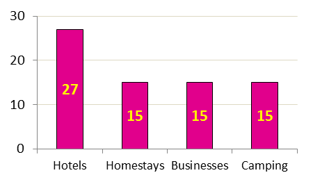 Figure 1:
Counts of where we stayed during the 72 nights on the road. There’s
also roadside camping, but this is often difficult for us since we can’t see
well. Finding a spot that’s legitimate
to camp can often be challenging. You
have to keep your eyes opened for a spot to camp in late afternoon just before calling
it a day. And you have to try to find a
spot that’s hidden from the road. No
need to have the local police interrogate you in the middle of the night …as happened
to us in Tennessee. But after hearing our
story, the tone quickly changed. They were
in awe and couldn’t ask enough questions about our vision and our ride. People are generally good; give them a chance and
they’ll prevail. Roadside
camping can be fun because of the freedom, but difficult because of the
possibilities of unwanted attention. Although,
along remote highways in the Southwest, it was easy because we could ride late into
the day before getting off and walking straight into the desert to camp. And the howls of coyotes at night make the
experience rugged, conjuring images of covered wagons passing through during the
1800’s. These
are some of the over-night options; there are probably others. Pay-campsites and/or RV Parks are also
options. 3.
Gear The
gear list below is what we used for our ride.
Yours may be different, but at least it’ll give you an idea of what is
needed. We kept it simple to minimize
weight and space. Storage space on a tandem
is limited, usually not more than a single bike. People on tandems often pull a trailer for
additional space. For our upcoming ride
through the Americas, we’ll be pulling a trailer since we’ll be carrying
cold-weather gear. ü
Bike ·
Front & rear racks/panniers ·
Spare tubes, patch kits, & pump ·
Tools for basic repairs ·
Bike lock ü
Camping ·
1 two-person tent ·
2 sleeping bags, 2 sleeping mats ·
2 headlamps ·
1 stove[2] ·
1 cooking pot (2 quarts) ·
2 spoons, 1 knife ·
2 plastic bowls ü
Clothing
(per person) ·
1 pair cycling shorts ·
2 cycling jerseys (1 is okay) ·
2 pairs cycling socks ·
1 pair cycling gloves (optional) ·
1 helmet ·
1 light jacket ·
1 t-shirt for off-bike ·
1 pair shorts for off-bike ·
1 hat for off-bike ·
1 pair of flip-flops for off-bike Note: You can
always pick up whatever you need along the way. ü
Electronics ·
Cyclometer ·
GPS ·
Camera ·
Christi used an mp3 player ·
FM radio for local news/music ü
Toiletries ·
Toothbrushes/toothpaste ·
Suntan lotion Well,
that’s pretty much it for gear. Keep it
simple and only carry what you need. Oh,
we also carried 44-oz plastic cups for Gatorade or soda refills at convenient
stores. Getting these ice-cold refills ($0.59-$0.89)
made the day! Search
around various websites to gather more information to plan your trip! Having done such
a ride, we now have a greater sense of what human power can do. Great distances can be covered, and adventures
can be had given the desire to do so. More information can
be found on the 2B2R website > Info > 2B2R Documents > Our Ride Across America 2009. Join us as we
ride the Americas and help us raise awareness about blindness and the abilities
of the blind. [1] The Trans-America Bike Path is a popular route that follows a network of roads and highways from Astoria, Oregon to Yorktown, Virginia. Internet search it. [2] We used an MSR Whisperlite
(uses white gas, which can be found in most Walmarts cross
the country). For 72 days, cooking
mostly dinners every night, we used approximately 60 fluid ounces of white gas. Top of Page © 2011 Two Blind to Ride |